.png)

Location & connectivity
Nobel Park,
a place to call home
a place to call home
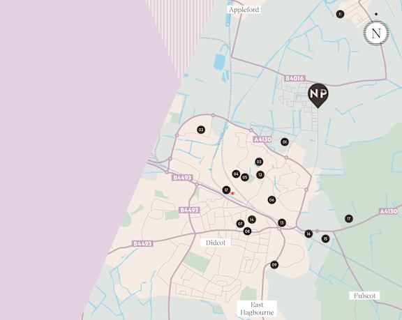
Set on the outskirts of the growing and vibrant Didcot town, this community offers you the best of both worlds. Tranquil green surroundings with the convenience of local amenities on your doorstep so you can enjoy a lifestyle that's both peaceful and well-connected.


Effortless connections
Norwich offers excellent travel links, making it easy to reach popular locations both within the region and beyond.
 By Road:
- Oxford 23 min
- Great Yarmouth 30 min
- Bicester 40 min
- Cotswolds 1 hr
 By Bus:
- ALDI Supermarket 7 min
- Didcot Parkway Train Station 18 min
- Abingdon 49 min
- Oxford 57 min
 By Train:
- Reading 11 min
- Swindon 15 min
- Oxford 33 min
- London Paddington 36 min
.png) By Bike:
By Bike:
- Didcot Parkway Train Station 9 min
- Tesco Superstore 10 min
- Didcot Town Centre 11 min
- Long WIttenham 11 min
Norwich is well-connected by a network of major roads linking you with major cities or with the coast, ensuring smooth travel to various destinations:
A147
Arrive in the city centre in 11 minutes
A11
This primary route links Norwich to London and the Midlands via Cambridge.
A47
Connecting Norwich to Great Yarmouth in the east and Peterborough in the west, the A47 is a crucial corridor for regional travel.
A140
Running south from Norwich to Ipswich, the A140 provides another important link to the southern region.
With a stop less than a minute walk away, travelling by bus is easy and accessible.
City5
Passing through Salhouse Road, this route connects Rackheath to Norwich City Centre, with a service arriving every 30 minutes.
Arrive on this service to Castle Meadow and pick up the 14 bus to take you directly to Norwich Train Station in just 3 minutes!
Sprowston Park & Ride
A reliable service that takes you into the city, stopping by Norwich Castle in 38 minutes, a 5 minute drive away from Woodland Heath.
As a major rail hub, Norwich railway station provides frequent and reliable services to several key destinations:
London Liverpool Street
1 hour 50 minutes
Direct trains to London,, making it convenient for business or leisure trips to the capital.
Cambridge
1 hour 20 minutes
A direct service to Cambridge, ideal for accessing this historic university city.
Ipswich
40 minutes
Regular services to Ipswich are available with a short journey time.
Norwich City Council provides a wealth of information on the cycle routes that connect the city centre with surrounding areas.
One of these routes is the Pink Pedalway that runs along Salhouse Road just moments from your doorstep. This takes you from Heartsease, through the heart of the city centre, all the way to the Norfolk & Norwich Hospital on the city’s west side.
Pink Pedalway
One of these routes is the Pink Pedalway that runs along Salhouse Road just moments from your doorstep. This takes you from Heartsease, through the heart of the city centre, all the way to the Norfolk & Norwich Hospital on the city’s west side.
A hub of opportunity
Set between picturesque countryside and a growing town, Didcot is a dynamic, welcoming area full of potential. Enjoy retail and dining at The Orchard Centre or discover unique local goods at the weekly market. For nature lovers, explore the scenic beauty of Wittenham Clumps or take a peaceful stroll around Ladygrove Lake. With easy access to Oxford via Didcot Parkway, there's something for everyone right on your doorstep.
.png)




Local schools
Didcot and Oxford provides families with a wide selection of high-quality educational institutions, guaranteeing that children have access to outstanding schooling options from primary through to college.
*Distances taken from Google Maps.


.png)